-------✦ INTRODUCTION ✦------
GPS Map Camera APP is the ultimate tool for adding geotags and detailed information to your photos.
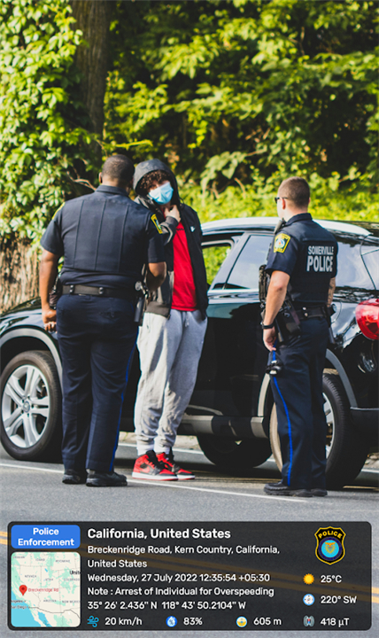
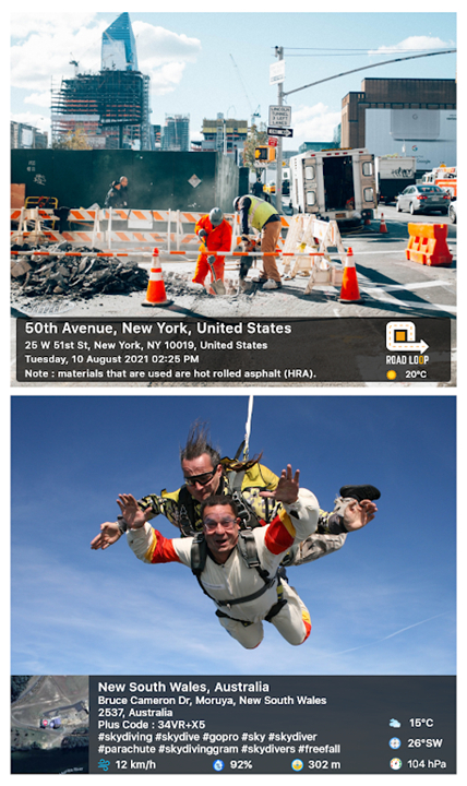
Whether you're traveling or simply want to remember a special place, this app allows you to add datetime, live maps, latitude, longitude, weather, magnetic field, compass, and altitude to your camera photos.
--------✦ KEY FEATURES ✦------
Custom GPS Camera
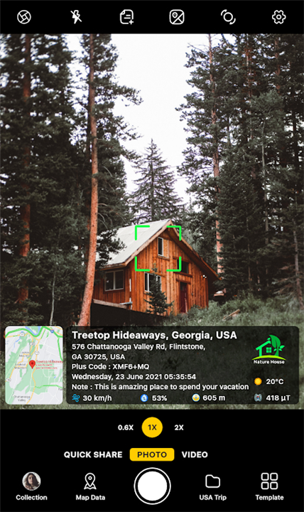
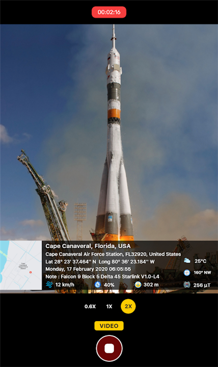
GPS Map Camera APP provides a custom GPS camera with options like grid, ratio, front & selfie camera, flash, focus, mirror, timer, dashcamera level, capture sound support, scenes, and filters. This feature allows you to take high-quality photos with all the necessary geotagging details.
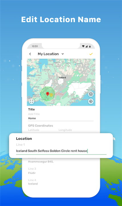
Set Photo Map Data
Choose between automatic or manual settings for your photo map data. This flexibility ensures that you can customize the geotagging details according to your preferences. Whether you want precise GPS coordinates or general location information, the app allows you to set it up as needed.
QR Code Scanner
The app includes a QR code scanner for fast and easy scanning. This feature adds an extra layer of functionality, making it convenient to scan and store relevant information.
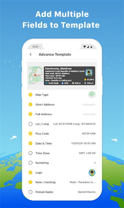
Classic and Advanced Templates
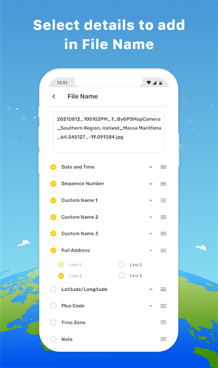
The app offers both classic and advanced templates for geotagging. The classic template automatically fetches stamp details, while the advanced template provides options to change photo map types, add short or full addresses, set GPS coordinates, and more. This ensures that you have the flexibility to choose the level of detail you want to add to your photos.
--------✦ PHONE REQUIREMENTS ✦------
- Compatible with both iOS and Android devices
- Requires a minimum of iOS 12 or Android 8.0
- Ensures optimal performance and access to all features
--------✦ RECOMMENDED AUDIENCES ✦----
GPS Map Camera APP is perfect for travelers, explorers, real estate professionals, architects, event organizers, bloggers, and anyone who wants to add detailed geotags and environmental data to their photos.
FAQ :
Q: How do I add GPS map location to my photos using the app?
A: Install the app, open the camera, select advanced or classic templates, arrange formats of stamps, and click photos to automatically add geolocation stamps.
Q: Can I set the photo map data manually?
A: Yes, you can choose between automatic or manual settings for your photo map data, allowing you to customize the geotagging details.
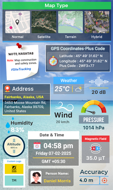
Q: Does the app support adding weather information to photos?
A: Absolutely! You can add weather information (Fahrenheit or Celsius), compass directions, magnetic field, wind speed, humidity, pressure, altitude, and accuracy to your photos.
Q: Is there an option to add logos and hashtags to my photos?
A: Yes, you can customize your photos by adding your brand logo and relevant hashtags, making them more personalized and discoverable.
------------------------------------------
Contact us at the following sites if you encounter any issues:
Official website: Here
------------------------------------------
What's New in the Latest Version 1.6.21
Last updated on Feb 26, 2025
- Now Map Data is Locations
- Added Video stamp
- Added Camera Tracking stamp
- Quick Share an image with a location link
- QR Code Detection on/off
We're regularly making changes and improvements. To ensure you don't miss a thing, keep your Updates turned on.
- AppSize68.00M
- System Requirements5.0 and up
- Is there a feeFree(In game purchase items)
- AppLanguage English
- Package Namecom.gpsmapcamera.geotagginglocationonphoto
- MD5
- PublisherGPS Map Camera
- Content RatingTeenDiverse Content Discretion Advised
- Privilege19
-
GPS Map Cameras 1.6.22Install
68.00M2025-04-19Updated
-
GPS Map Camera 1.8.2Install
3.61M2025-04-19Updated


8.8
7684 Human Evaluation
- 5 Star
- 4 Star
- 3 Star
- 2 Star
- 1 Star