About Tracklia: GPX, KML, KMZ & maps
Tracklia is a versatile mapping tool designed to simplify your GPX, KML, and KMZ file workflows. Whether you're planning trips, editing files, or navigating, Tracklia provides robust features to manage and share mapping data efficiently.
Features
Work with GPX, KML, KMZ Files:
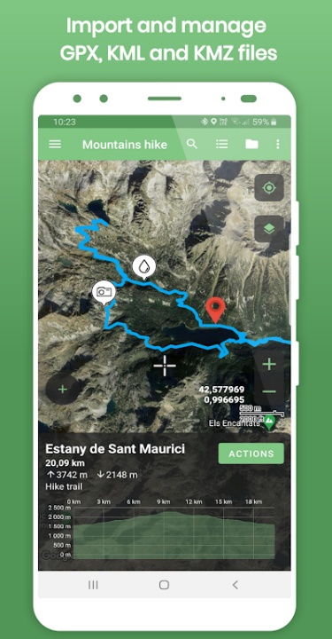
- Import tracks, routes, areas, and waypoints selectively, avoiding unnecessary data.
- Record GPS tracks with elevation graphs, distance, and ascent/descent details.
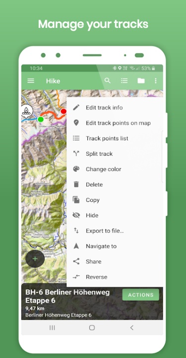
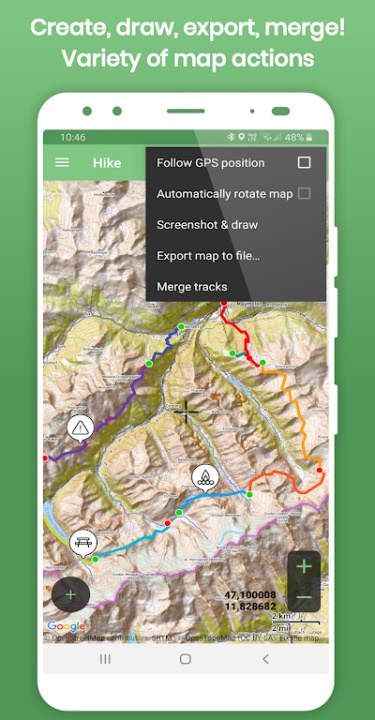
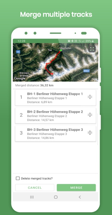
- Merge multiple tracks interactively or split long tracks into manageable parts.
- Reverse tracks and share files directly to navigation apps like Google Maps.
Advanced Editing Tools:
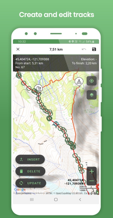
- Add, update, delete, or insert points within tracks, routes, and areas.
- Rename and change descriptions for tracks, waypoints, and areas.
- Delete multiple points simultaneously, update waypoint locations/icons, and adjust settings.
File Export Options:
- Create new tracks and areas, measure polygons, and add waypoints.
- Export data to GPX, KML, or CSV files for easy sharing and further use.
- Draw directly on maps with fingertip precision and send as images.
GPX Data Management:
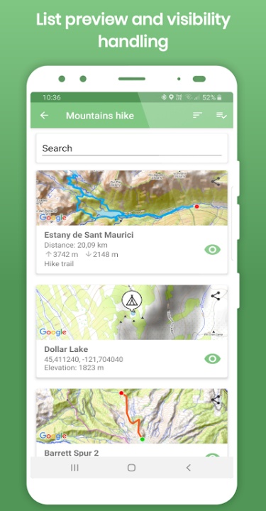
- Group and store GPX, KML, and KMZ files within app memory using "My Maps List."
- Edit and save data for upcoming trips, and share files with friends effortlessly.
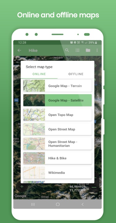
Diverse Map Options:
- Access offline maps like Open Street Map for uninterrupted navigation.
- Utilize online maps including Google Maps (Normal, Terrain, Satellite), Open Topo Map, CyclOSM, and Esri Aerial.
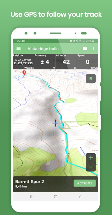
Navigation Features:
- Display current GPS position on maps and follow it continuously.
- Rotate maps based on GPS bearing and view GPS details (accuracy, coordinates, speed).
- Use offline maps for navigation in remote areas.
Supported Languages
- Tracklia is available in multiple languages, including Deutsch, English, Español, Français, हिन्दी, Português, Русский, Türkçe, Tiếng Việt, and more.
Benefits
- Ease of Use: Provides simple tools for editing, managing, and exporting mapping data.
- Flexible Mapping Options: Supports offline and online maps for versatility in navigation.
- Powerful Features: Facilitates advanced track management with merging, splitting, and exporting functionalities.
Frequently Asked Questions
Q: Can I record GPS tracks using Tracklia?
A: Yes, you can record and view elevation graphs, distances, and ascent/descent details.
Q: What map options are available?
A: Tracklia supports both offline maps (e.g., Open Street Map) and online maps (e.g., Google Maps Terrain, Esri Aerial).
Q: Can I share my mapping files?
A: Absolutely, you can export and share files in GPX, KML, or CSV formats with friends or apps.
Q: Does Tracklia support waypoint editing?
A: Yes, you can update waypoint locations, icons, and descriptions.
Q: Can I use Tracklia as a navigation tool?
A: Yes, Tracklia offers GPS tracking, map rotation, and offline navigation capabilities.
Version History
v1.17.0 ---- 27 Feb 2024
- Bug fixes and improvements.
v1.16.2 ---- 18 Dec 2024
- Bug Fixes and improvements.
v1.15.0 ---- 28 Jul 2024
- Bug fixes and improvements.
- AppSize17.00M
- System Requirements5.0 and up
- Is there a feeFree(In game purchase items)
- AppLanguage English
- Package Nameapp.tracklia
- MD5
- PublisherTracklia Inc.
- Content RatingTeenDiverse Content Discretion Advised
- Privilege19
-
Tracklia: GPX, KML, KMZ & maps 1.17.0Install
17.00M2025-03-31Updated


7.5
6367 Human Evaluation
- 5 Star
- 4 Star
- 3 Star
- 2 Star
- 1 Star